Click map to enlarge![]()
Hawaiian Petrels
Click map to enlarge![]()
MNSRP used geo-locators tags to describe the at-sea behavior of Hawaiian Petrels from the island of Lāna‛i that were raising chicks. The results showed that individual birds alternate between short, nearby foraging trips, and long distance trips around the North Pacific while feeding chicks.
Wedge-tailed Shearwaters
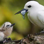
![]() In a study funded in part by the Bureau of Oceans Energy Management (BOEM), there is a collaborative effort to understand seasonal variability in at-sea behaviors and their relationship to chick growth of various seabird species throughout the Hawaiian Islands.
In a study funded in part by the Bureau of Oceans Energy Management (BOEM), there is a collaborative effort to understand seasonal variability in at-sea behaviors and their relationship to chick growth of various seabird species throughout the Hawaiian Islands.
MNSRP participates in this study by deploying and recovering GPS tags on Wedge-tailed shearwaters at colonies in Maui Nui.
For more information about this study, please click here.